
Discover powerful Dolibarr extensions designed to automate your business processes
1. Overview
Geolocation & Telematics turns...
Couldn't load pickup availability


1. Overview
Geolocation & Telematics turns Dolibarr into a full connected-fleet management platform inspired by DigiParc telematics solutions. It brings real-time GPS tracking, geofencing, event alerting, eco-driving analysis, fuel monitoring and decision-grade reporting directly into the Dolibarr ERP, tightly integrated with the native Third Parties and Users modules.
The module is designed for fleet operators, logistics companies, delivery and field-service organisations that need to know, at any moment, where their vehicles are, how they are being driven, and to be alerted the instant something requires attention — a speeding event, a vehicle leaving an authorised zone, an unauthorised movement, or a low device battery.
Key benefits
· Real-time visibility — live position, speed, engine state and last activity of every tracked vehicle on a single supervision board.
· Proactive alerting — instant alerts for speeding, zone exits, unauthorised movements and harsh driving, ranked by severity.
· Cost control — fuel-consumption tracking (L/100km, cost, idle time), maintenance planning and eco-driving scores that reduce operating costs.
· Compliance & security — geofence perimeters, remote immobilisation and a complete audit trail of trips, positions and zone crossings.
· Decision reporting — 12-month trends and breakdowns for distance, fuel, alerts, driver behaviour and fleet composition.
2. Functional Scope
The module is organised around sixteen business objects, seven permission groups, a real-time dashboard, a live supervision board and a decision-reporting workspace.
2.1 Real-time tracking & supervision
· Vehicle tracking — each vehicle carries its live state (moving, stopped, immobilised, offline), current speed, last known position, last activity time, daily distance and driving score.
· Supervision board — a live table of the whole fleet (plate, driver, live status with colour dot, speed, position, eco-score, last alert) with instant filtering by status.
· GPS positions — time-stamped position history (latitude, longitude, speed, heading, ignition state, location label).
2.2 GPS devices & drivers
· Telematics devices — the physical GPS boxes: serial, IMEI, SIM number, model, firmware, battery level, last communication and status (active, inactive, in maintenance, out of service).
· Drivers — driver records with licence details, assigned vehicle, eco-driving score, total mileage, number of trips and number of alerts.
2.3 Geofencing
· Zones — geofences defined as a circle (radius), a polygon, or a segment/corridor, classified by category (warehouse, construction site, logistics centre, restricted zone, customer zone, car park), each with its own speed limit, protected-perimeter flag and active-monitoring flag.
· Zone crossings — every entry and exit event, flagged authorised or unauthorised, with time and speed.
· Points of interest — customers, depots, fuel stations, car parks, workshops and head office with address and coordinates.
2.4 Trips & activity
· Trips — completed and in-progress journeys with start/end time and location, distance, driving duration, stop time, average and maximum speed, number of stops and segments, fuel consumed and odometer readings.
· Daily reports — a per-vehicle daily activity summary (departure, return, distance, fuel, active duration, number of trips, top speed).
2.5 Alerts, behaviour & notifications
· Telematics alerts — speeding, zone exit/entry, unauthorised movement, harsh braking, harsh acceleration, excessive idling, fuel anomaly and low battery; each with a severity (information, warning, critical) and a workflow status (new, seen, handled).
· Driving behaviour — eco-driving events feeding the driver and vehicle scores.
· Notification rules — configurable multi-channel routing (e-mail, SMS, push, webhook) per alert type and threshold.
· Remote immobilisation — commands to immobilise or release a vehicle, with reason, requester and execution status.
2.6 Fleet operations
· Fuel & consumption — consumption records (distance, litres, L/100km, idle minutes, cost).
· Maintenance — oil change, service, tyres, brakes, repair and electronic diagnostics, planned / completed / overdue.
· Documents — registration cards, insurance certificates, telematics reports, device contracts, photos and invoices attached to vehicles.
3. Business Object Model
The sixteen objects and the permission group that governs each of them:
|
Object |
Purpose |
Permission group |
|
Vehicle |
Tracked asset with live state and score |
Vehicles & devices |
|
Device |
GPS / telematics box |
Vehicles & devices |
|
Driver |
Driver file and eco-score |
Drivers & behaviour |
|
Driving behaviour |
Eco-driving events |
Drivers & behaviour |
|
Trip |
Journey history and live trips |
Tracking |
|
GPS position |
Time-stamped position pings |
Tracking |
|
Point of interest |
Customers, depots, stations… |
Tracking |
|
Zone (geofence) |
Circle / polygon / segment areas |
Geofencing |
|
Zone crossing |
Entry / exit events |
Geofencing |
|
Alert |
Real-time telematics alerts |
Alerts |
|
Notification rule |
Multi-channel alert routing |
Alerts |
|
Immobilisation |
Remote immobilise / release |
Alerts |
|
Fuel record |
Consumption and cost |
Fleet operations |
|
Maintenance |
Servicing and repairs |
Fleet operations |
|
Daily report |
Per-vehicle daily activity |
Fleet operations |
|
Document |
Attached vehicle documents |
Fleet operations |
4. Dashboard & Reporting
4.1 Real-time dashboard
The dashboard is organised into four zones:
· Fleet & real-time tracking — total vehicles, moving, stopped, immobilised, offline, active devices, drivers and drivers on mission.
· Activity & trips — trips today, distance today, distance this month, average speed, plus 12-month distance and fuel-consumption charts.
· Driving & consumption — average eco-score and device-online gauges, average consumption, monthly fuel volume and cost, driving-events and fuel-mix charts.
· Alerts & geofences — an alert-severity breakdown donut, open/critical alert counters, speeding and zone crossings today, active zones, unauthorised exits, and a live table of the most recent open alerts.
4.2 Reporting workspace
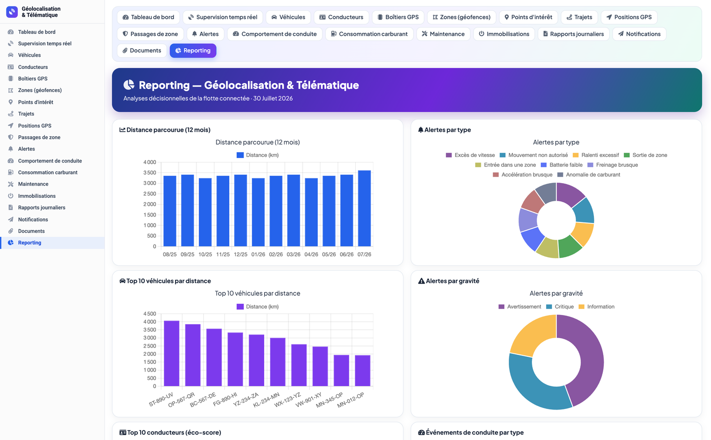
Decision analytics include: distance travelled (12 months), fuel consumption (12 months), alerts raised (12 months), alerts by type and by severity, top 10 vehicles by distance, top 10 drivers by eco-score, driving events by type, fleet by status, by fuel type and by branch, zone crossings by zone, and devices by status.
5. Integration & Technical Notes
· Native integration — depends on the Third Parties module; author/owner links to native Users.
· Permissions — seven groups (Vehicles & devices, Drivers & behaviour, Tracking, Geofencing, Alerts, Fleet operations, Reporting) with read / write / delete rights; read & write granted by default on activation.
· Navigation — a dedicated top menu, a full left menu, an in-page tab bar, a dashboard, a supervision board and a reporting page.
· Demo dataset — a realistic Moroccan fleet demonstration dataset (vehicles, drivers, devices, geofences, trips, alerts, fuel, maintenance…) is installed on activation and can be reset from the setup page.
· Configuration — default speed limit, speeding-alert threshold, excessive-idling threshold and new-alert notification toggle.
· Compatibility — Dolibarr 16.0 and above, PHP 7.1 and above; currency displayed in Moroccan dirham (MAD).
© 2026 DoliResources — www.doliresources.com


