
Discover powerful Dolibarr extensions designed to automate your business processes


1. Overview
Topographic Survey Office Management (technical name surveyofficemanagement) is a professional, commercial-grade business module that transforms Dolibarr ERP/CRM into a complete, specialised management solution for a topographic / land-surveying office. It covers the full range of a survey firm’s technical, administrative, commercial and financial activities within a single, natively integrated platform.
Built entirely with an object-oriented, modular and maintainable architecture that follows the official Dolibarr development standards, the module ships with 24 business objects, a premium dashboard, a mission Kanban board, 21 decision-support reports, a document library, an automation engine and a first-activation demonstration dataset. It is responsive (desktop, tablet, mobile), dark-mode compatible, secured (CSRF, XSS, prepared/escaped SQL, fine-grained permissions) and multi-company (MultiCompany) aware.
Module identity
|
Commercial name |
Gestion Cabinet Topographique |
|
Technical name |
surveyofficemanagement |
|
Version |
1.0.0 |
|
Publisher |
DoliResources - www.doliresources.com |
|
Module number |
505300 (family: Projects) |
|
Compatibility |
Dolibarr v16, v17, v18, v19, v20, v21, v22, v23+ - PHP 7.1+ |
|
Languages |
French, English, Spanish, Italian, German |
|
Dependencies |
Third parties (modSociete), Products/Services (modProduct) |
|
SQL table prefix |
llx_surveyoffice_ |
|
Business objects |
24 (object-oriented, extend CommonObject) |
2. Functional Scope
The module manages, end to end, every business area of a surveying practice:
· Topographic project management with GPS coordinates and native Dolibarr project linkage
· Field mission management with a drag-and-drop Kanban workflow
· Topographic surveys (GPS, GNSS RTK, total station, drone, Lidar, levelling, traversing, networks, buildings, roads)
· Setting-out (implantation) of buildings, utilities (VRD), roads and structures with control checks
· Boundary marking (bornage) with boundary marks, coordinates, photos and official reports (PV)
· Cadastral and land management: parcels, land titles, subdivisions, land division and regrouping
· Plans and deliverables (topographic, cadastral, VRD, as-built, DTM, orthophoto) in DWG/DXF/LandXML/PDF/SHP
· Geographic data: points, coordinate systems, projections and datums (open architecture, GIS-ready)
· Equipment and instrument fleet with maintenance and calibration tracking
· Field teams and technical staff (surveyors, technicians, drone operators, drivers) with timesheets
· Commercial management: quotes, contracts, native invoicing and payments
· Financial management: budgets, expenses, revenue, mission costs, profitability and margins
· Quality control: inspections, verifications, non-conformities and audits
· Document management (GED), decision reporting and workflow automation
3. Modern Dashboard
The reworked "Survey office cockpit" gives management an at-a-glance operational and financial picture, styled with a dedicated topographic/geomatics visual identity (cartographic blue, terrain green, technical grey, signalling orange, sky blue).
Technical alert tiles
Five live alert tiles surface what needs attention now: missions behind schedule, instruments due for calibration, open non-conformities, drones available and total stations available.
Premium KPI cards (4 zones, 28 indicators)
· Overview: projects, missions in progress, completed missions, late missions, average progress, total budget, active clients, average hours per mission.
· Field operations: surveys carried out, setting-outs, boundary markings, plans produced, cadastral parcels, land titles, subdivisions.
· Equipment & teams: total equipment, available equipment, total stations available, drones available, calibrations due, field teams, technical staff.
· Commercial & finance: revenue, issued invoices, active contracts, expenses, profitability rate, non-conformities.
Mission board & dynamic charts
· Mission stage board summarising missions per workflow stage.
· Mission progress bar chart (top active missions).
· Survey-type distribution pie chart.
· Revenue evolution over 12 months.
· Equipment availability pie chart.
The dashboard is fully responsive and dark-mode compatible.
4. Project Management
Each topographic project centralises: reference, name, client, location, GPS coordinates, coordinate system, budget, project manager, start/end dates, progress and status, together with the linked native Dolibarr project. A project acts as a hub that aggregates all related missions, parcels, plans, documents and financial entries, with full history.
5. Mission Management
Missions are the operational heart of the module. Each mission records its type, client, team, lead surveyor, assigned equipment, location and GPS coordinates, priority, start/end dates, workflow stage, progress and notes. Supported mission types:
· Topographic surveys
· Setting-out (implantation)
· Boundary marking
· As-built surveys
· Levelling
· Traversing / polygonals
· GNSS surveys
· Drone surveys
· Cadastral plans
· Utility (VRD) plans
· Digital Terrain Models (DTM)
· Orthophotos
Mission Kanban board
A drag-and-drop Kanban board drives missions through their lifecycle in six columns: Planned -> Field work -> Computation -> Drawing -> Control -> Delivered. Moving a card instantly updates the mission stage and status (AJAX, no page reload). Each card shows progress and prestation type.
6. Topographic Surveys
Every survey documents its type, mission, instrument used, surveyor, date, number of points, precision (mm), coordinate system, area (ha) and the associated data file. Supported survey techniques:
· GPS
· GNSS RTK
· Total station
· Drone (photogrammetry)
· Lidar / 3D laser scanning
· Levelling
· Traversing
· Polygonals
· Network surveys
· Building surveys
· Road surveys
7. Setting-out (Implantation)
Setting-out operations are tracked by type (building, utilities/VRD, road, structure), surveyor, date, number of points, tolerance (mm) and control result, providing traceable proof of on-site staking accuracy.
8. Boundary Marking, Cadastral & Land Management
Boundary marking (bornage)
Each boundary operation records its type (amicable/judicial), related project, client and parcel, number of marks, surveyor, official report (PV) reference, date and workflow stage (in progress, report drawn, signed, filed). Every boundary mark stores its type (OGE marker, stone, iron, PVC tube), X/Y/Z coordinates and photo - the basis of a complete boundary report.
Cadastral parcels
Parcels capture section, parcel number, owner, third party, area (sq.m), land use, title reference and GPS coordinates.
Land titles
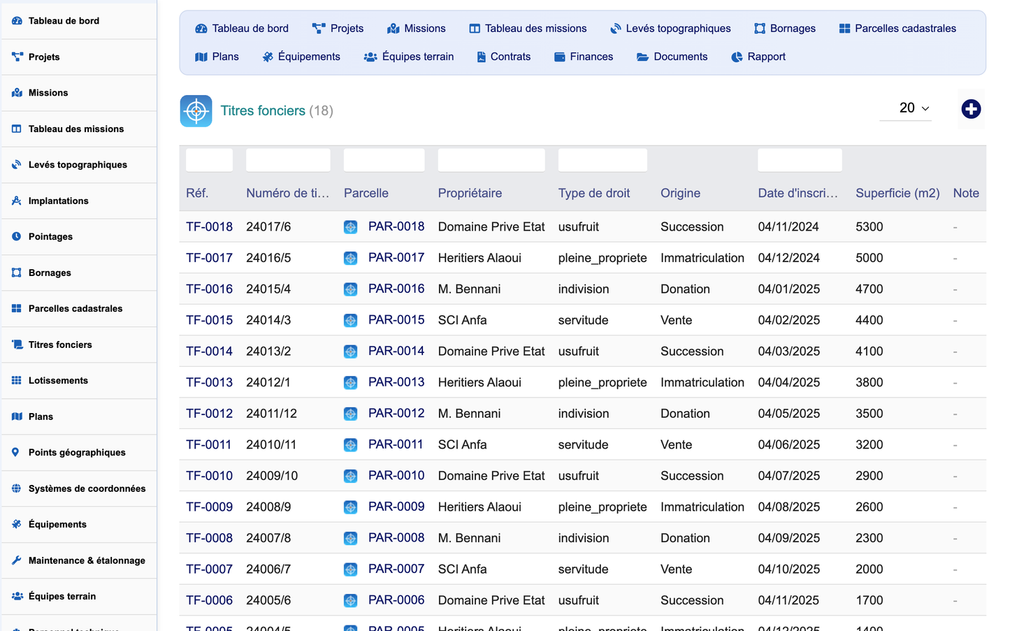
Land titles record the title number, related parcel, owner, right type (full ownership, usufruct, easement, joint ownership), origin, registration date and area.
Subdivisions
Subdivisions (lotissement), land divisions and regroupings are managed with type, number of lots, total area, approval reference, approval date and status.
9. Equipment & Instruments
The instrument fleet covers total stations, GNSS receivers, levels, drones, laser scanners, theodolites, staffs and vehicles. Each item tracks its type, brand, model, serial number, availability, current mission, purchase value, last and next calibration dates. A maintenance/calibration sub-record logs each intervention (type, date, cost, provider, certificate reference, next due date), supporting metrological traceability.
10. Plans & Geographic Data
Plans and deliverables
Plans are catalogued by type (topographic, cadastral, VRD, as-built, layout, setting-out, DTM, orthophoto) with scale, file format (DWG, DXF, LandXML, PDF, SHP), version, date and file path.
Geographic points and reference systems
The module stores geographic points (code, mission, X/Y/Z coordinates, point type, coordinate system, description) and a library of coordinate systems, projections and datums (EPSG code, projection, datum, ellipsoid, zone, unit, default flag) - an open architecture ready for future GIS integration.
11. Field Teams & Staff
Field teams are organised by role (survey brigade, setting-out, boundary, drone, levelling) with a team leader, headcount, vehicle and phone. Technical staff (geometer-experts, surveyors, technicians, drone operators, drivers) are recorded with role, team, certification, contact details and daily cost. Timesheets link staff time to missions (task, date, hours, activity) for productivity and cost analysis.
12. Commercial & Financial Management
Quotes and contracts are managed within the module and rely exclusively on Dolibarr native objects for the commercial and accounting flow. Contracts record type (framework, agreement, per-diem), amount, signature and validity dates and can generate native invoices. Financial tracking captures budgets, expenses and revenue by category, payment mode and project, feeding profitability and margin analysis (revenue vs. analytical expenses).
13. Quality Control
The quality module records inspections, verifications, non-conformities and audits, each with type, related mission, control date, controller, result and status - closing the quality loop on survey deliverables.
14. Document Management (GED)
The document library indexes plans (DWG/DXF), LandXML exports, PDFs, reports, official reports (PV), photos, orthophotos, cadastral extracts and contracts, with categorisation, versioning, archiving and a direct link to Dolibarr’s native ECM. Documents can be filtered by type and browsed by category.
15. Decision Reporting
A dedicated reporting hub offers 21 cross-cutting reports, each exportable to CSV, Excel and print:
· Missions by type
· Missions by stage (progress)
· Late missions (deadlines)
· Surveys by type
· Setting-outs by type
· Boundary markings by type
· Parcels by land use
· Projects by type
· Plans by type/format
· Equipment by type
· Equipment availability
· Maintenance by type
· Teams by role
· Staff by role
· Quotes by status
· Contracts by type
· Quality by type
· Expenses by category
· Revenue by month
· Profitability by project
· Clients by number of missions
16. Automation Engine
A rules-based automation engine runs daily via the Dolibarr scheduler (cron) and on demand. Out of the box it closes delivered missions, flags instruments whose calibration is overdue and maintains an execution counter per rule. Rules define a trigger event, condition, action type, parameters and delay.
17. Native Dolibarr Integration
All commercial and accounting operations use exclusively Dolibarr native objects. The module integrates natively with: Third parties, Contacts, Products/Services, Projects, Agenda, Quotes, Orders, Invoices, Payments, Banking, Accounting, Contracts, Interventions, Emails and the ECM (document management).
18. Security & User Interface
Security
· CSRF protection (tokens on create/edit actions)
· XSS protection (systematic output escaping)
· Prepared / escaped SQL queries
· Fine-grained permissions across 14 object groups + reporting + administration (44 rights)
· Logging and audit trail; referential-integrity triggers on third-party / user deletion
· Multi-entity (MultiCompany) compatibility
User interface
· Modern, elegant, responsive design (PC, tablet, mobile)
· Global search and multi-criteria filtering
· Dynamic tables with a show/hide column selector
· Interactive widgets and KPI cards
· Mission Kanban view and project timeline
· Status badges, modern FontAwesome icons and dark-mode support
19. Technical Architecture & Demo Data
The module follows the official Dolibarr module architecture: core/modules (descriptor), class (24 CommonObject business classes), sql (tables and indexes), langs (5 languages), css/js (responsive charter), img, lib (shared library and object registry), core/boxes (dashboard widget), core/triggers (integrity) and doc. All SQL tables use the llx_surveyoffice_ prefix. A first-activation demonstration dataset (clients, projects, missions, surveys, parcels, equipment, teams, plans, contracts, documents and finance) can be installed or removed in one click from the configuration page; removal deletes only demo data created by the module.


